
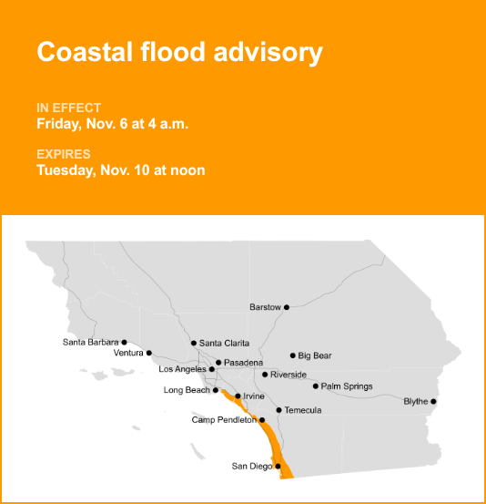
Orange County Coast and San Diego County Coastal Areas are under a coastal flood advisory which was released by the National Weather Service on Wednesday at 12:42 p.m. The advisory is valid from Friday 4 a.m. until Tuesday Nov. 10, at noon.
“Minor to locally moderate coastal flooding expected. Additionally, dangerous rip currents and surf of 3 to 5 feet expcted along west-facing beaches,” according to the NWS San Diego CA. “Coastal residents and managers of infrastructure in the advisory area should prepare for rising water and take appropriate action to protect life and property. Highest tides will occur in the late morning each day. Observed high tides are 1.3 to 1.6 feet above astronomical tide predictions. Surf will increase starting next Monday, but there is uncertainty in details at this time.”
“Flooding of lots, parks, and roads with only isolated road closures expected,” the NWS said. “If travel is required, allow extra time as some roads may be closed. Do not drive around barricades or through water of unknown depth. Take the necessary actions to protect flood-prone property.”
Understanding the differences between advisories, watches, and warnings
Flash flood warning: Take action.
A flash flood warning is issued when a flash flood is either imminent or already occurring. In flood-prone areas, it’s crucial to move immediately to higher ground. A flash flood is a sudden and violent inundation that can develop within minutes to hours, and it can even happen in areas not currently experiencing rainfall.
Flood warning: Take action.
A flood warning is issued when flooding is imminent or occurring.
Flood advisory: Be aware.
A flood advisory is released when flooding is not expected to reach a severity level necessitating a warning. Nonetheless, it can still cause considerable inconvenience and, without exercising caution, potentially lead to situations that threaten life and/or property.
Flood watch: Be prepared.
A flood watch is issued when conditions are favorable for flooding. It doesn’t guarantee that flooding will occur, but it signifies that the possibility exists.
Weathering the storm: Flood safety guidelines from the NWS
In flood-prone regions or while camping in low-lying areas, understanding and following the NWS flood safety guidelines can be a lifesaver:
Seek higher ground:
If you reside in a flood-prone region or are camping in low-lying terrain, the first step to safety is relocating to higher ground.
Adhere to evacuation orders:
If local authorities issue an evacuation order, heed it promptly. Prior to leaving, secure your home by locking it.
Disconnect utilities and appliances:
If time permits, disconnect your utilities and appliances. This precaution minimizes electrical hazards during flooding.
Avoid basements and submerged areas:
Avoid basements or rooms submerged in water with electrical outlets or cords. Preventing electrical accidents is crucial.
Evacuate promptly for safety:
If you notice sparks or hear buzzing, crackling, snapping, or popping sounds, evacuate without delay. Do not enter water that may carry an electrical charge.
Stay away from floodwaters:
Never attempt to walk through floodwaters, even if they appear shallow. Just 6 inches of fast-moving water can forcefully sweep you off your feet.
Seek higher ground when trapped:
Should you become trapped by moving water, reach the highest point possible and dial 911 to contact emergency services.
During heavy rainfall, there is a risk of flooding, especially in low-lying and flood-prone areas. Remember to never drive through water on the road, even if it seems shallow. According to the NWS, as little as 12 inches of rapidly flowing water can carry away most cars. Prioritize your safety by staying informed and prepared.
For more local weather alerts, visit our Weather Advisory page