
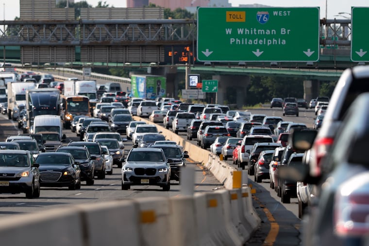
Even in an age where driving is as safe as it has ever been, hundreds of people still die on New Jersey roads each year.
Across South Jersey, an analysis shows, there are seven corridors that are particularly problematic — stretches where four or more people have died in crashes in the last seven years.
The Inquirer analyzed about 330 fatal crashes across South Jersey’s limited-access highways, which led to more than 360 deaths between 2019 and July 2026, according to New Jersey Department of Transportation data.
Drive north along I-76 to Philly or take Route 42 south to the Shore, and you will likely cross one of South Jersey’s most dangerous sections. The interchange where I-76 meets Route 42 and I-295, in Camden County, has recorded some of the highest rates of fatal accidents in the region, as city commuters, long-haul truckers, and beachgoers navigate a snarled intersection.
I-76 in South Jersey runs five lanes wide in both directions and spans only three miles, but each mile has seen fatalities. And within a 1.3-mile stretch, 10 fatal crashes occurred, more deaths than on any other highway segment. On the mile of I-295 leading up to the I-76 merge, four fatalities occurred.
“There are a whole bunch of reasons why, around intersections, you have accidents,” said Chris Pollard of the Delaware Valley Regional Planning Commission.
Highways like I-76 with tricky merges, heavy congestion, and sharp bends are more likely to be fatal than calmer sections of road, Pollard said. When cars go around curves or merge at high speeds around other, slower-moving vehicles, accidents are more likely.
“It’s often based on the geography of the road,” Pollard said.
Distracted driving played a role in nearly half of South Jersey’s fatal car crashes, contributing to more than 140 deaths, while alcohol was a factor in more than 75 fatal accidents.
Other dangerous hotspots in South Jersey include a mile stretch of I-295 in Oldmans Township, Salem County, where seven fatal crashes occurred, a half-mile stretch of the New Jersey Turnpike in Mount Laurel Township, Burlington County, with four fatal crashes, and a 0.6-mile stretch of I-676 before the Ben Franklin Bridge, with four fatal crashes.
A recent call for safer highways
A string of fatal crashes on one of South Jersey’s safer highways this summer has legislators asking questions.
Since July, four crashes have killed five people on Route 55, a 40-mile freeway that runs from Cumberland County up to the Route 42 entrance in Deptford.
In response to the string of crashes, Assemblyman William Moen, a Democrat in the New Jersey Legislature, cosigned a letter with eight other politicians to NJDOT, urging the department to examine how Route 55’s design could have led to the deaths.
Moen’s social media post about the highway reached more people, about 200,000, than any post he has made in his decade as an elected official, he said. The interactions showed him the public wants answers, too.
“There’s always that question of, ‘Could there be things that are being used on other highways that the state operates that simply aren’t in place on Route 55?’” Moen said.
Unlike some of the region’s more complex roadways, Route 55 is only two lanes, and has few, if any, sharp bends.
Still, 46 people have died on the highway between 2019 and this July. One 0.64-mile-long segment of Route 55, by Elk Township, Gloucester County, has seen a high volume of fatal crashes, four total, in recent years. That included a crash that killed three teenagers last year.
As a result of the letter, NJDOT is in talks with legislators to “identify safety improvements needed along the corridor,” according to Steve Schapiro, an NJDOT spokesperson. Miranda Toner, Moen’s spokesperson, said the assemblyman has since been briefed by NJDOT on the matter and has received an official letter from the department outlining plans for Route 55.
In January 2025, the legislature approved the New Jersey Target Zero Commission, created to eliminate “all traffic fatalities and serious injuries” on public roadways by 2040.
Part of that law required NJDOT to track the state’s fatal crash data through its High-Injury Network, which flagged one-mile segments of public roadways with seven or more fatal or serious-injury crashes between 2021 and 2023. Since NJDOT updates the map every three years, recent crash data will not be available there until 2028.
No segments of Route 55 are currently featured on the network, but various miles of roadways throughout Camden, Gloucester, Burlington, and Cumberland County made the list.
Schapiro said 90% of state-maintained, one-mile segments on the High-Injury Network, which includes 88 locations, are currently undergoing projects, and the rest will start safety projects, too. Plus, the department regularly uses its data to identify high-risk areas, crash patterns, trends, vulnerable populations, and driving times.
Enjoyed this story?
Get more South Jersey news on your homepage with one click.